

Remote Sensing & Economics
IGEP INVESTIGATOR: K. MOELTNER
MOUNTAIN PINE BEETLE AND HOME VALUES
The Mountain Pine Beetle (MPB), a native forest pest, has damaged large areas of forestland in the western United States. We are interested in the effect of this infestation on local home values. This requires remote-sensing information on a variety of spatial features surrounding a given home, including tree damage.
WATER USE AND CONSERVATION
We manage several ongoing projects in the Reno / NV area on residential water use and conservation. All of them require remote-sensing type information on the exact locations of homes, home owners associations (HOAs), and landscape features. For example, we are interested to see if households that receive different types of appeal letters for conservation reduce outdoor irrigation. We also want to know if there are "spillover" effects - do their neighbors also react to those letters, even though they themselves did not receive one? Exact remote sensing information and geo-coding are crucial to answer these questions.
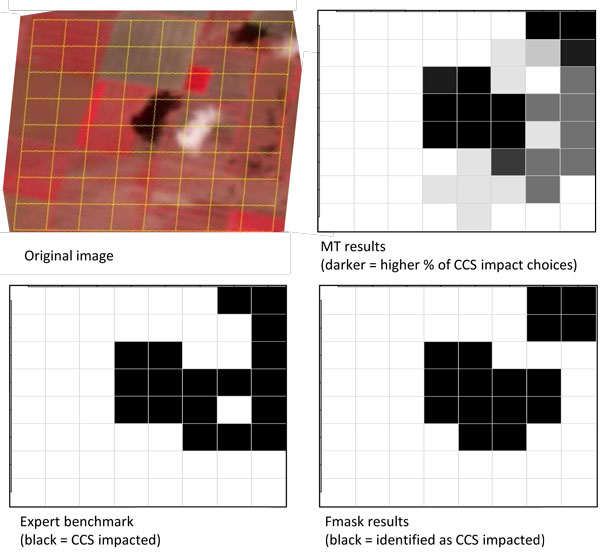
LABOR CONTRACTS FOR CLOUD IDENTIFICATION
Images collected through remote sensing need to be examined for cloud and cloud shadow before they can be utilized for further analysis. Given the large volume of images and the limited training and expertise needed to perform this task, we envision outsourcing this work to a global community of online cloud identifiers (CIs). However, little is known about the productivity and quality of work that can be expected from such an arrangement under different incentive structures. We are therefore conducting labor experiments at Amazon.com's Mechanical Turk online labor market to see how wages, image complexity, experience, and payment scheme affect performance. This yields insights on how to design optimal contracts when we go "global." These experiments are also providing important guidance to the remote sensing community with respect to the relative strengths of human interpreters and computational algorithms in detecting clouds and cloud shadow for different satellite scenes and cloud covers.
See also:
Yu , L., S. B. Ball, C. E. Blinn, K. Moeltner, S. Peery, V.A. Thomas, R. H. Wynne (2015). Cloud-Sourcing: Using an Online Labor Force to Detect Clouds and Cloud Shadows in Landsat Images. Remote Sensing, 7(3), 2334-2351, https://www.mdpi.com/2072-4292/7/3/2334