

Natural Resources
Applications
We have many remote sensing applications related to natural resources, several of which are described under the other headings. Our major research areas are:
FOREST RESOURCES
IGEP Investigators: R. Wynne, V. Thomas, D.-Y. Kim, K. Moeltner
ECOSYSTEM SERVICES
IGEP Investigators: R. Wynne, V. Thomas
We have developed a spatially-explicit, web-based ecosystem services toolkit to help land managers quantify the impact of land management scenarios on carbon, water quality, and biodiversity. Our continued efforts in this area will also include marginal agriculture and air quality. Some of our modules are already publically accessible.
LAND USE/COVER CHANGE
IGEP Investigators: Y. Shao, J. Campbell, R. Wynne, V. Thomas, D.-Y. Kim
We have several efforts in this area, mainly using satellite multispectral systems such as Landsat and MODIS. An example is the work of Dr. Shao, as follows:
My research focuses on geospatial techniques (GIS, remote sensing, and spatial analysis) and their applications in land use/cover change, watershed assessment, and water quality monitoring. I develop tools that enable rapid and inexpensive methods to assess land use and land cover change. I am also integrating land cover change analysis with watershed-scale environmental assessments. The tools enable conservation organizations and government agencies to better understand the consequences of environmental and energy policies in agricultural and forested landscapes.
WETLANDS, WATERSHEDS, AND WATER QUALITY
IGEP Investigators: Y. Shao, K. Moeltner, V. Thomas, R. Wynne
AGRICULTURE
IGEP Investigators: Y. Shao, J. Campbell
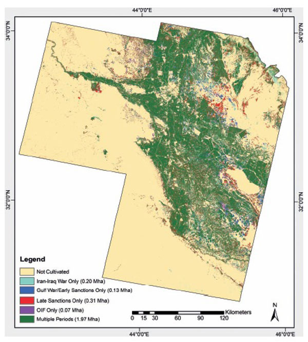
EXAMPLE: FOOD SECURITY IN IRAQ
Gibson, G. R., J. B. Campbell, and R. H. Wynne. 2012. Three Decades of War and Food Insecurity in Iraq. Photogrammetric Engineering & Remote Sensing. Vol. 78, pp. 885-895.
This image shows the agricultural region near Baghdad, supported by irrigation, almost entirely by surface water diverted from the major rivers of the region. The green pattern shows areas continuously in cultivation, using irrigation, since the 1980's, compiled using sequential satellite imagery. The various other colored regions show areas where irrigated agriculture was expanded, in various episodes, as Iraq attempted to expand its agricultural production during the Iran-Iraq War, the period of UN Sanctions, and other conflicts that have disrupted the Iraqi economy during the past decades. These are areas where agriculture expanded, then was never used again, these are, then, areas of failed attempts to expand agricultural lands, which were later abandoned due to salinization and other forms of soil and water degradation. Although some of these area seem very small on this image, many are immense irrigation projects that have been abandoned due to declining environmental quality.